The NSW Government is creating one of Australia’s largest infrastructure and city shaping programs, the 11,200-hectare Western Sydney International Airport Precinct. (formerly known as Western Sydney Aerotropolis)
The precinct will become integral to Greater Sydney and NSW, and it will transform the area into a thriving cultural, social and economic hub. The government is ensuring local communities and industry are connected to the precinct by safe, reliable, and integrated public transport and roads.
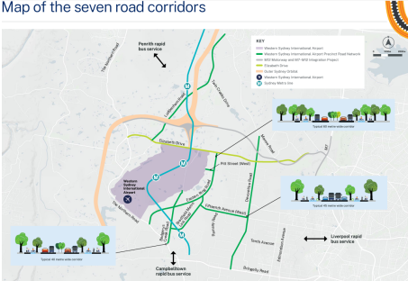
A road network is being developed which identifies seven key corridors for future development. The below image contains the roads:

The business case for staging i.e: which road to be built first, will be completed by December 2023.
https://yoursay.transport.nsw.gov.au/western-sydney-international-airport-precinct-road-network
Transport for NSW is seeking your feedback on future roads connecting to the Western Sydney International Airport Precinct. We would like to invite you to have your say on the proposed future transport use of these roads.
The NSW Government is creating one of Australia’s largest infrastructure and city shaping programs, the 11,200-hectare Western Sydney International Airport Precinct.
The precinct will become integral to Greater Sydney and NSW, and it will transform the area into a thriving cultural, social and economic hub.
We are ensuring local communities and industry are connected to the precinct by safe, reliable, and integrated public transport and roads.
We invite you to have your say on the Precinct Road Network that is being developed to support the project. Take our survey below.
What is the Precinct Road Network
The Precinct Road Network is made up of corridors that will provide access to Western Sydney International Airport. They will assist movement around surrounding communities, as well as within the precinct itself. The network will cater for all road use including freight, public transport, cycling and walking.
The State Environmental Planning Policy (Precincts - Western Parkland City) featured a transport network for the future city.
Transport has identified seven key corridors(External link) from this network. We are progressing development of the corridors for future transport connectivity. These corridors are:
Customer Service Manager:Michael Guo
Tel:0430680555
Email:office@ksiinvestments.com.au
Address:Suite 404, 53 Walker Street, North Sydney, NSW, 2060
General advice warning and Disclaimers
